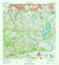
1969 Map of Aguas Buenas
USGS Topo · Published 1972About this map
Aguas Buenas and the surrounding municipalities of Guaynabo, San Juan, and Caguas appear here during a period of significant suburban expansion and infrastructure development in the late 1960s. The landscape is defined by the winding course of the Rio Grande de Loiza and the expansive Lago Loiza, which serves as a central hydrological feature. Residential developments like Beverly Hills, Parkville, and Villa Clementina illustrate the growing urbanization spreading south from San Juan. Local educational and social history is deeply embedded in the map's numerous rural schools, such as Escuela Mamey Centro and Escuela Hato Nuevo, alongside specialized institutions like the Antilles Military Academy and the Leprocomio. From the industrial Cantera sites to the religious landmarks like Nuestra Senora del Pilar, the map documents the varied social fabric of the region.
Find a feature on this map
100 named features on this map. Tap any name to fly to it.
Don’t see what you’re looking for? This feature index may not catch every label — zoom into the map to look around manually.
Map Details
Editions of this 1969 Aguas Buenas Map
4 editions found
Other maps of this area

1940 · Carolina
USGS Topo · 1:30,000

1941 · Bayamon
USGS Topo · 1:30,000

1941 · San Juan
USGS Topo · 1:30,000

1941 · Carolina
USGS Topo · 1:30,000

1946 · Aguas Buenas
USGS Topo · 1:30,000

1946 · Comerio
USGS Topo · 1:30,000

1946 · Naranjito
USGS Topo · 1:30,000

1946 · Gurabo
USGS Topo · 1:30,000

1946 · Juncos
USGS Topo · 1:30,000

1946 · Caguas
USGS Topo · 1:30,000