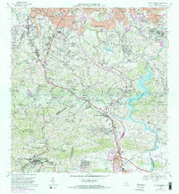
1969 Map of Aguas Buenas
USGS Topo · Published 1982About this map
Aguas Buenas sits at the southwestern corner of this survey, serving as a gateway to the mountainous interior south of the San Juan metropolitan area. By the late 1960s, the urban expansion of Guaynabo and Monacillo Urbano was beginning to reach southward into the rural barrio lands of Tortugo and Frailes. The landscape is defined by the significant hydrological system feeding Lago Loiza, where the Rio Caguitas and Rio Bairoa converge. This map captures a moment of transition where large institutions like the Antilles Military Academy and the Leprocomio existed alongside traditional rural schools such as Escuela Antonio Longa and Escuela Jagueyes. The presence of several radio towers, including Antena de Radio (WAPA) and Antena de Radio (WKAQ-TV), highlights the region's importance as a communications hub for the island's capital due to its elevated topography.
Find a feature on this map
138 named features on this map. Tap any name to fly to it.
Don’t see what you’re looking for? This feature index may not catch every label — zoom into the map to look around manually.
Map Details
Editions of this 1969 Aguas Buenas Map
4 editions found
Other maps of this area

1940 · Carolina
USGS Topo · 1:30,000

1941 · Bayamon
USGS Topo · 1:30,000

1941 · San Juan
USGS Topo · 1:30,000

1941 · Carolina
USGS Topo · 1:30,000

1946 · Aguas Buenas
USGS Topo · 1:30,000

1946 · Comerio
USGS Topo · 1:30,000

1946 · Naranjito
USGS Topo · 1:30,000

1946 · Gurabo
USGS Topo · 1:30,000

1946 · Juncos
USGS Topo · 1:30,000

1946 · Caguas
USGS Topo · 1:30,000