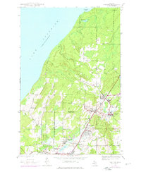
1946 Map of Ahmeek
USGS Topo · Published 1976About this map
The copper-rich Keweenaw Peninsula is captured here in the mid-1940s, with updates from the 1970s reflecting the industrial and social landscape of northern Michigan. Mining operations are central to the region's geography, anchored by the Ahmeek Mine and the Red Jacket Mine. A dense network of company towns and settlements like Bumbletown, Phillipsville, and Centennial Heights cluster around the mineral veins, connected by transportation routes such as the Old Railroad Grade.
Find a feature on this map
34 named features on this map. Tap any name to fly to it.
Don’t see what you’re looking for? This feature index may not catch every label — zoom into the map to look around manually.
Map Details
Editions of this 1946 Ahmeek Map
3 editions found
Other maps of this area

1915 · Houghton
USGS Topo · 1:62,500

1941 · Ahmeek
USGS Topo · 1:31,680

1941 · Mohawk
USGS Topo · 1:31,680

1946 · Phoenix
USGS Topo · 1:24,000

1946 · Hancock
USGS Topo · 1:24,000

1946 · Mohawk
USGS Topo · 1:24,000

1946 · Muggun Creek
USGS Topo · 1:24,000

1946 · Ahmeek
USGS Topo · 1:24,000

1946 · Laurium
USGS Topo · 1:24,000

1947 · Phoenix
USGS Topo · 1:24,000