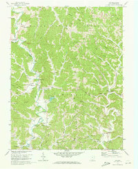
1972 Map of Aid
USGS Topo · Published 1973About this map
The rugged valleys of southern Ohio's coal and timber country are defined by the winding course of Symmes Creek and the protective canopy of the Wayne National Forest. In the early 1970s, this landscape preserved a traditional Appalachian settlement pattern of ridge-top farms and valley-floor hamlets like Willow Wood and Dobbston. Evidence of the region's industrial and agricultural life is scattered throughout the terrain, from a Strip Mine near Rapp Ridge to the Lookout Tower monitoring the timberlands. Cultural roots run deep here, marked by numerous rural sanctuaries and burial grounds such as New Zion Ch and the Zimmerman Cem. The infrastructure of the era is remarkably preserved, featuring a Covered Bridge on Indian Guyan Creek and the consolidated Symmes Valley High Sch, which served the disparate hollows and ridges of Aid and Mason townships.
Find a feature on this map
83 named features on this map. Tap any name to fly to it.
Don’t see what you’re looking for? This feature index may not catch every label — zoom into the map to look around manually.
Map Details
Editions of this 1972 Aid Map
4 editions found
Other maps of this area

1892 · Huntington
USGS Topo · 1:125,000

1898 · Huntington
USGS Topo · 1:125,000

1898 · Ironton
USGS Topo · 1:62,500

1900 · Ironton
USGS Topo · 1:62,500

1901 · Guyandot
USGS Topo · 1:62,500

1901 · Ceredo
USGS Topo · 1:62,500

1902 · Guyandot
USGS Topo · 1:62,500

1903 · Kenova
USGS Topo · 1:125,000

1904 · Kenova
USGS Topo · 1:125,000

1906 · Athalia
USGS Topo · 1:62,500