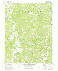
1972 Map of Aid
USGS Topo · Published 1978About this map
Symmes Creek winds through the heart of the Wayne National Forest in this early 1970s view of Lawrence County, where small agricultural settlements and extractive industries define the landscape. The map captures a transition in the local economy, showing numerous Strip Mines and scattered Gas Wells interspersed with rural schools and community centers like the Jr High Sch in Dobbston and Symmes Valley High Sch near Aid. Family history is deeply rooted in the terrain here, evident in the many named burial grounds such as Kingrey Cem and Zimmerman Cem. The transportation network is anchored by small hubs like Willow Wood and Scottown, while natural features like Greasy Ridge and Ellsworth Ridge dictate the placement of roads and homesteads above the creek valleys.
Find a feature on this map
89 named features on this map. Tap any name to fly to it.
Don’t see what you’re looking for? This feature index may not catch every label — zoom into the map to look around manually.
Map Details
Editions of this 1972 Aid Map
4 editions found
Other maps of this area

1892 · Huntington
USGS Topo · 1:125,000

1898 · Huntington
USGS Topo · 1:125,000

1898 · Ironton
USGS Topo · 1:62,500

1900 · Ironton
USGS Topo · 1:62,500

1901 · Guyandot
USGS Topo · 1:62,500

1901 · Ceredo
USGS Topo · 1:62,500

1902 · Guyandot
USGS Topo · 1:62,500

1903 · Kenova
USGS Topo · 1:125,000

1904 · Kenova
USGS Topo · 1:125,000

1906 · Athalia
USGS Topo · 1:62,500