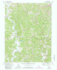
1972 Map of Aid
USGS Topo · Published 1985About this map
Wayne National Forest dominates much of this Lawrence County landscape, characterized by a complex system of ridges and hollows that historically dictated settlement patterns. Small communities and family centers such as Aid, Willow Wood, and Scottown are established along the valley floors, primarily following the winding course of Symmes Creek and Indian Guyan Creek. The presence of numerous Gas Wells and scattered Strip Mines across the northern reaches, particularly along Ellsworth Ridge, indicates a local economy deeply tied to resource extraction during the mid-20th century.
Find a feature on this map
72 named features on this map. Tap any name to fly to it.
Don’t see what you’re looking for? This feature index may not catch every label — zoom into the map to look around manually.
Map Details
Editions of this 1972 Aid Map
4 editions found
Other maps of this area

1892 · Huntington
USGS Topo · 1:125,000

1898 · Huntington
USGS Topo · 1:125,000

1898 · Ironton
USGS Topo · 1:62,500

1900 · Ironton
USGS Topo · 1:62,500

1901 · Guyandot
USGS Topo · 1:62,500

1901 · Ceredo
USGS Topo · 1:62,500

1902 · Guyandot
USGS Topo · 1:62,500

1903 · Kenova
USGS Topo · 1:125,000

1904 · Kenova
USGS Topo · 1:125,000

1906 · Athalia
USGS Topo · 1:62,500