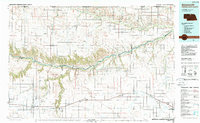
1985 Map of Ainsworth
USGS Topo · Published 1988About this map
The Niobrara River carves a deep path through the Nebraska Sandhills, serving as the central geographic axis for this 1980s landscape. To the north, the Keya Paha River defines the borderlands near the South Dakota-Nebraska state line, winding past small agricultural outposts like Springview and Burton. The map captures a moment when the Chicago and North Western railroad still connected the string of southern towns including Ainsworth, Long Pine, Bassett, and Newport. This rail corridor, shadowed by U.S. Highway 20, provides a clear view of the region's transport-driven settlement pattern. The transition from the flat plateau of Flat Table and Long Pine Table into the steep breaks of the Thomas Creek State Wildlife Management Area illustrates the dramatic change from prairie ranchland to river valley ecology.
Find a feature on this map
56 named features on this map. Tap any name to fly to it.
Don’t see what you’re looking for? This feature index may not catch every label — zoom into the map to look around manually.
Map Details
Editions of this 1985 Ainsworth Map
2 editions found
Other maps of this area

1949 · Dutch Creek
USGS Topo · 1:24,000

1949 · Jamison SW
USGS Topo · 1:24,000

1949 · Riverview
USGS Topo · 1:24,000

1949 · Carns
USGS Topo · 1:24,000

1950 · Bassett NW
USGS Topo · 1:24,000

1950 · Norden
USGS Topo · 1:62,500

1950 · Carns
USGS Topo · 1:24,000

1950 · Riverview
USGS Topo · 1:24,000

1950 · Meadville
USGS Topo · 1:24,000

1950 · Huddle Table
USGS Topo · 1:24,000