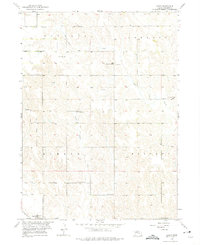
1954 Map of Akron
USGS Topo · Published 1975About this map
Boone County, Nebraska, is characterized here by a dense network of one-room schoolhouses and agricultural townships in the mid-1950s. The settlement of Akron sits in the northwest corner, serving a landscape divided into named townships including Bonanza, Dublin, Rose, and Elma. This era of the Missouri River Basin development shows a rural community structure still reliant on local landmarks like School No 79 and the Red Sch. In the southwest, the village of Primrose is reached by the Up RR, illustrating the critical role of rail transport for prairie towns. Waterways like Plum Creek and Silver Valley Creek dictate the topography, while family history is grounded in the Akron Cem and Dennison Cem. The distribution of facilities such as Pleasant Valley Sch and School No 86 reflects the peak of the rural school system before consolidation changed the Nebraska interior.
Find a feature on this map
18 named features on this map. Tap any name to fly to it.
Don’t see what you’re looking for? This feature index may not catch every label — zoom into the map to look around manually.
Map Details
Editions of this 1954 Akron Map
Other maps of this area

1954 · Cedar Rapids
USGS Topo · 1:24,000

1954 · Spalding
USGS Topo · 1:24,000

1954 · Akron
USGS Topo · 1:24,000

1954 · Albion West
USGS Topo · 1:24,000

1954 · Cedar Rapids SE
USGS Topo · 1:24,000

1954 · Spalding SE
USGS Topo · 1:24,000

1955 · Broken Bow
USGS Topo · 1:250,000

1956 · Broken Bow
USGS Topo · 1:250,000

1960 · Spalding 2 SE
USGS Topo · 1:24,000

1963 · Petersburg
USGS Topo · 1:24,000