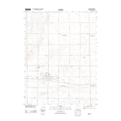
2013 Map of Akron
USGS Topo · Published 2013About this map
Akron serves as the central hub of this Eastern Plains landscape, defined by a rigid grid of county roads that carve the high plains into precise sections. The town's layout is centered on the corridor of E Railroad Ave and Wheat St, reflecting the vital role of transit in this agricultural and energy-producing region. Local history is anchored at the Akron Cem and Saint Joseph's Cem, while the northern reaches are marked by the drainage of Twenty-two Slough.
Find a feature on this map
40 named features on this map. Tap any name to fly to it.
Don’t see what you’re looking for? This feature index may not catch every label — zoom into the map to look around manually.
Map Details
Editions of this 2013 Akron Map
This is the sole edition of this map. No revisions or reprints were ever made.
Other maps of this area

1951 · Merino SE
USGS Topo · 1:24,000

1954 · Sterling
USGS Topo · 1:250,000

1958 · Sterling
USGS Topo · 1:250,000

1973 · Akron
USGS Topo · 1:24,000

1973 · Platner
USGS Topo · 1:24,000

1973 · Fremont Butte
USGS Topo · 1:24,000

1973 · Pinneo SE
USGS Topo · 1:24,000

1973 · Buffalo Springs Ranch SE
USGS Topo · 1:24,000

1973 · Akron SE
USGS Topo · 1:24,000
1973 · Buffalo Springs Ranch
USGS Topo · 1:24,000