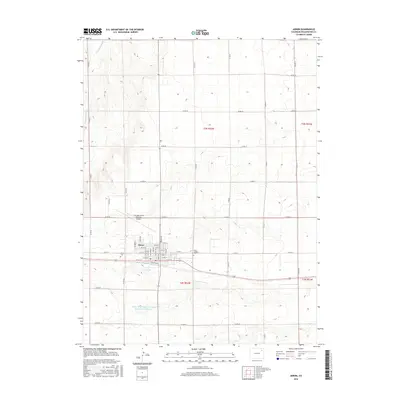
2016 Map of Akron
USGS Topo · Published 2016About this map
Akron serves as the focal point of this high plains landscape, organized by a precise grid of county roads and residential streets. The town's layout is grounded by its transit history, with Railroad Ave running parallel to the primary tracks that once drove local commerce. Water management is central to the area's utility, evidenced by the Akron Reservoir and the Akron-Washington Company Recreation Reservoir to the south. Local heritage is preserved at the Akron Cem and Saint Joseph's Cem, while the Colorado Plains Regional Airport northwest of town marks the modern transition of this agricultural hub. The surrounding terrain is defined by drainage features like Twentytwo Slough, which cuts through the northwestern sections of the survey.
Find a feature on this map
48 named features on this map. Tap any name to fly to it.
Don’t see what you’re looking for? This feature index may not catch every label — zoom into the map to look around manually.
Map Details
Editions of this 2016 Akron Map
This is the sole edition of this map. No revisions or reprints were ever made.
Other maps of this area

1951 · Merino SE
USGS Topo · 1:24,000

1954 · Sterling
USGS Topo · 1:250,000

1958 · Sterling
USGS Topo · 1:250,000

1973 · Akron
USGS Topo · 1:24,000

1973 · Platner
USGS Topo · 1:24,000

1973 · Fremont Butte
USGS Topo · 1:24,000

1973 · Pinneo SE
USGS Topo · 1:24,000

1973 · Buffalo Springs Ranch SE
USGS Topo · 1:24,000

1973 · Akron SE
USGS Topo · 1:24,000
1973 · Buffalo Springs Ranch
USGS Topo · 1:24,000