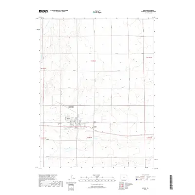
2019 Map of Akron
USGS Topo · Published 2019About this map
Akron serves as the focal point of this Eastern Colorado landscape, exhibiting a classic high plains grid system defined by the intersection of major thoroughfares like W 1st St and Grand Ave. The town's civic importance is anchored by the Washington County Courthouse, while its aviation role is represented by the Colorado Plains Regional Airport to the north. Water management in this semi-arid region is evident through features such as the Akron Reservoir and the Akron-Washington Company Recreation Reservoir, which support both local utilities and recreation. Genealogists will find the locations of Akron Cem and Saint Joseph's Cem useful for local research. Beyond the town limits, the terrain is characterized by the drainage of Twentytwo Slough and a vast network of county roads like Co RD 42 and Co RD 88 that partition the surrounding agricultural sections.
Find a feature on this map
51 named features on this map. Tap any name to fly to it.
Don’t see what you’re looking for? This feature index may not catch every label — zoom into the map to look around manually.
Map Details
Editions of this 2019 Akron Map
This is the sole edition of this map. No revisions or reprints were ever made.
Other maps of this area

1951 · Merino SE
USGS Topo · 1:24,000

1954 · Sterling
USGS Topo · 1:250,000

1958 · Sterling
USGS Topo · 1:250,000

1973 · Akron
USGS Topo · 1:24,000

1973 · Platner
USGS Topo · 1:24,000

1973 · Fremont Butte
USGS Topo · 1:24,000

1973 · Pinneo SE
USGS Topo · 1:24,000

1973 · Buffalo Springs Ranch SE
USGS Topo · 1:24,000

1973 · Akron SE
USGS Topo · 1:24,000
1973 · Buffalo Springs Ranch
USGS Topo · 1:24,000