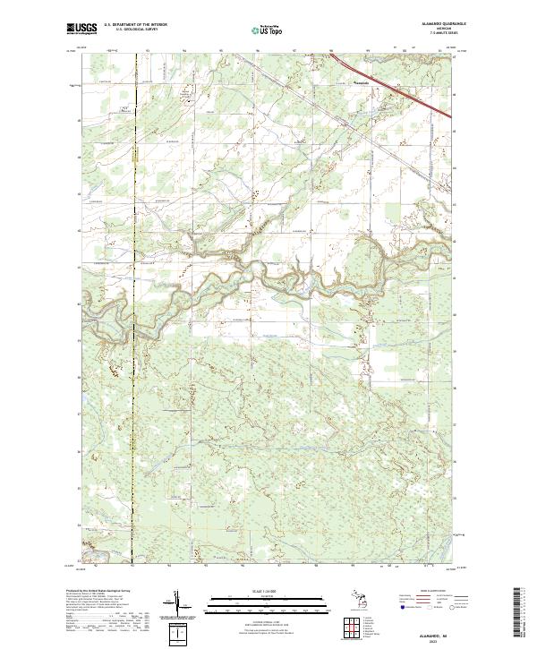
2023 Map of Alamando
USGS Topo · Published 2023About this map
Alamando sits at the northern edge of this Midland County landscape, a rural crossroads defined by its complex drainage network and early transportation corridors. The map documents the confluence of the North Branch Salt River and South Branch Salt River, where they join to form the main Salt River. To the south, the Chippewa River cuts through the terrain, supported by various artificial watercourses like Teed Drain and Carrol Creek Drain that signify the area's agricultural development.
Find a feature on this map
58 named features on this map. Tap any name to fly to it.
Don’t see what you’re looking for? This feature index may not catch every label — zoom into the map to look around manually.
Map Details
Editions of this 2023 Alamando Map
This is the sole edition of this map. No revisions or reprints were ever made.
Other maps of this area
1930 · Shepherd
USGS Topo · 1:48,000
1934 · Sanford
USGS Topo · 1:62,500
1936 · Shepherd
USGS Topo · 1:62,500
1936 · Sanford
USGS Topo · 1:62,500

1954 · Midland
USGS Topo · 1:250,000

1958 · Midland
USGS Topo · 1:250,000

1959 · Midland
USGS Topo · 1:250,000

1966 · Midland
USGS Topo · 1:250,000
1969 · Coleman
USGS Topo · 1:24,000
1969 · Edenville
USGS Topo · 1:24,000