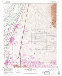
1960 Map of Alameda
USGS Topo · Published 1975About this map
Corrales and the surrounding valley lands of the Rio Grande define this stretch of the New Mexico landscape during a period of significant suburban expansion. While the western bank maintains a pocket of rural character around the San Ysidro Ch and Sandoval Sch, the eastern side of the river shows the northward reach of Albuquerque development. The interface between historical land grants like the Sandia Pueblo and modern infrastructure is evident in the alignment of the Atchison Topeka and Santa Fe railroad and the presence of the Coronado Airport. Numerous arroyos, including the Arroyo de Domingo Baca and Arroyo del Pino, cut westward from the foothills of the Cibola National Forest, illustrating the natural drainage patterns that have historically dictated settlement along the river's edge.
Find a feature on this map
40 named features on this map. Tap any name to fly to it.
Don’t see what you’re looking for? This feature index may not catch every label — zoom into the map to look around manually.
Map Details
Editions of this 1960 Alameda Map
Other maps of this area

1888 · Bernalillo
USGS Topo · 1:125,000

1889 · Albuquerque
USGS Topo · 1:125,000

1892 · San Pedro
USGS Topo · 1:125,000

1893 · Albuquerque
USGS Topo · 1:125,000

1934 · Alameda
USGS Topo · 1:24,000

1934 · West Albuquerque
USGS Topo · 1:24,000

1934 · Griegos
USGS Topo · 1:24,000

1934 · East Albuquerque
USGS Topo · 1:24,000

1938 · Albuquerque
USGS Topo · 1:62,500

1954 · Sandia Crest
USGS Topo · 1:24,000
Featured Places
- Albuquerque, NM
- Corrales, NM
- Los Ranchos de Albuquerque, NM
- Prospectors Ridge, Albuquerque
- Academy Ridge East, Albuquerque