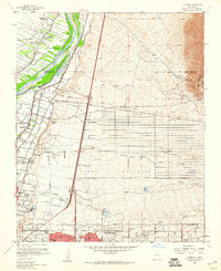
1960 Map of Alameda
USGS Topo · Published 1960About this map
The Rio Grande valley north of Albuquerque is defined by an intricate network of irrigation and drainage infrastructure, including the Corrales Main Canal, Riverside Drain, and Albuquerque Main Canal. This complex water system supports the agricultural character of Corrales and Alameda, where the Camino Real follows the river's path. To the east, the terrain rises sharply into the Elena Gallegos and the foothills of the Cibola National Forest, carved by numerous drainages like the Arroyo de Domingo Baca and Arroyo del Pino. Significant institutional landmarks are scattered throughout the landscape, from the Sandia View Academy and San Ysidro Ch in the north to the Academy for Boys and Nazareth Hospital further south. Industrial footprints, such as the Reeves Powerplant and various Gravel Pits, highlight the mid-century expansion near the Albuquerque city boundary.
Find a feature on this map
45 named features on this map. Tap any name to fly to it.
Don’t see what you’re looking for? This feature index may not catch every label — zoom into the map to look around manually.
Map Details
Editions of this 1960 Alameda Map
Other maps of this area

1888 · Bernalillo
USGS Topo · 1:125,000

1889 · Albuquerque
USGS Topo · 1:125,000

1892 · San Pedro
USGS Topo · 1:125,000

1893 · Albuquerque
USGS Topo · 1:125,000

1934 · Alameda
USGS Topo · 1:24,000

1934 · West Albuquerque
USGS Topo · 1:24,000

1934 · Griegos
USGS Topo · 1:24,000

1934 · East Albuquerque
USGS Topo · 1:24,000

1938 · Albuquerque
USGS Topo · 1:62,500

1954 · Sandia Crest
USGS Topo · 1:24,000
Featured Places
- Albuquerque, NM
- Corrales, NM
- Los Ranchos de Albuquerque, NM
- Prospectors Ridge, Albuquerque
- Academy Ridge East, Albuquerque