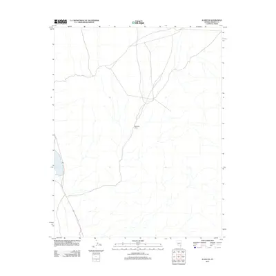
2012 Map of Alamo SE
USGS Topo · Published 2012About this map
Upper Pahranagat Lake anchors the southwestern edge of this Lincoln County landscape, where the high desert terrain meets a vital water source. The map follows the corridor of Highway 93 as it cuts through the arid expanse of Eightmile Valley, a characteristic desert basin defined by its drainage patterns and vast open space. This 2012 survey illustrates the path of modern infrastructure alongside historical routes, specifically noted by the inclusion of Old Hwy 93. The presence of these parallel thoroughfares highlights the evolution of transit through the Great Basin, showing where older desert tracks were replaced or bypassed by modern engineering to accommodate travel between the isolated valleys of southeastern Nevada.
Find a feature on this map
4 named features on this map. Tap any name to fly to it.
Don’t see what you’re looking for? This feature index may not catch every label — zoom into the map to look around manually.
Map Details
Editions of this 2012 Alamo SE Map
This is the sole edition of this map. No revisions or reprints were ever made.
Other maps of this area

1885 · Pioche
USGS Topo · 1:250,000

1886 · Pioche
USGS Topo · 1:250,000

1945 · Alamo
USGS Topo · 1:125,000

1954 · Caliente
USGS Topo · 1:250,000

1959 · Caliente
USGS Topo · 1:250,000

1969 · Alamo SE
USGS Topo · 1:24,000

1969 · Lower Pahranagat Lake
USGS Topo · 1:24,000

1969 · Alamo NE
USGS Topo · 1:24,000
1969 · Lower Pahranagat Lake NW
USGS Topo · 1:24,000
1969 · Delamar 3 NW
USGS Topo · 1:24,000