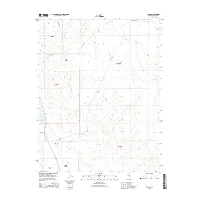
2015 Map of Alamo SE
USGS Topo · Published 2015About this map
The settlement of Alamo sits at the base of the Hiko Range in this modern topographic survey of Lincoln County. The landscape is defined by the stark transition between high desert peaks and the watered lowlands of the Pahranagat Valley, where Upper Pahranagat Lake provides a vital riparian anchor. A network of rural routes, including Joe Higbee Rd and Alamo Canyon Rd, traces the drainage patterns and historical access points into the mountains. Between the ridges of the Hiko and the eastern Pahroc Range lies the expanse of Eightmile Valley, showing the distinct geological structure typical of the Great Basin. This map detail illustrates how contemporary infrastructure like Old Buckhorn Rd continues to follow the natural contours of the valley floor, connecting the scattered springs and canyon mouths that have dictated movement in this region for generations.
Find a feature on this map
17 named features on this map. Tap any name to fly to it.
Don’t see what you’re looking for? This feature index may not catch every label — zoom into the map to look around manually.
Map Details
Editions of this 2015 Alamo SE Map
This is the sole edition of this map. No revisions or reprints were ever made.
Other maps of this area

1885 · Pioche
USGS Topo · 1:250,000

1886 · Pioche
USGS Topo · 1:250,000

1945 · Alamo
USGS Topo · 1:125,000

1954 · Caliente
USGS Topo · 1:250,000

1959 · Caliente
USGS Topo · 1:250,000

1969 · Alamo SE
USGS Topo · 1:24,000

1969 · Lower Pahranagat Lake
USGS Topo · 1:24,000

1969 · Alamo NE
USGS Topo · 1:24,000
1969 · Lower Pahranagat Lake NW
USGS Topo · 1:24,000
1969 · Delamar 3 NW
USGS Topo · 1:24,000