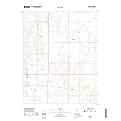
2018 Map of Alamo SE
USGS Topo · Published 2018About this map
Upper Pahranagat Lake anchors the southwestern corner of this survey, marking a vital water source in the arid basin of Lincoln County. The landscape is defined by the parallel elevations of the Hiko Range and the Pahroc Range, which frame the broad expanse of Eightmile Valley. This section of Nevada illustrates the stark transition between desert valley floors and the jagged limestone ridges characteristic of the Great Basin. The presence of Refuge Office Rd suggests the administrative and conservation efforts focused around the lake and its surrounding wetlands. Other transportation routes, such as Alamo Canyon Rd, follow the natural contours of the terrain, providing access into the higher elevations of the range. The map clearly delineates the Public Land Survey System township and range lines, including t7s r61e and t7s r62e, which remain foundational for land management in this sparsely settled region.
Find a feature on this map
10 named features on this map. Tap any name to fly to it.
Don’t see what you’re looking for? This feature index may not catch every label — zoom into the map to look around manually.
Map Details
Editions of this 2018 Alamo SE Map
This is the sole edition of this map. No revisions or reprints were ever made.
Other maps of this area

1885 · Pioche
USGS Topo · 1:250,000

1886 · Pioche
USGS Topo · 1:250,000

1945 · Alamo
USGS Topo · 1:125,000

1954 · Caliente
USGS Topo · 1:250,000

1959 · Caliente
USGS Topo · 1:250,000

1969 · Alamo SE
USGS Topo · 1:24,000

1969 · Lower Pahranagat Lake
USGS Topo · 1:24,000

1969 · Alamo NE
USGS Topo · 1:24,000
1969 · Lower Pahranagat Lake NW
USGS Topo · 1:24,000
1969 · Delamar 3 NW
USGS Topo · 1:24,000