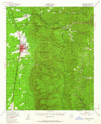
1950 Map of Alamogordo
USGS Topo · Published 1963About this map
Alamogordo and the surrounding high desert foothills of the Sacramento Mountains are depicted here during a period of significant post-war expansion. The town center is densely detailed, showing the Fairgrounds, the State Sch For Blind, and the Alamogordo Airport. To the west, the edge of the Holloman A.F. Base and the White Sands Airport signal the area's growing military importance.
Find a feature on this map
74 named features on this map. Tap any name to fly to it.
Don’t see what you’re looking for? This feature index may not catch every label — zoom into the map to look around manually.
Map Details
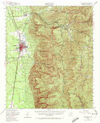
Editions of this 1950 Alamogordo Map
Other maps of this area

1916 · Tularosa
USGS Topo · 1:125,000

1916 · Point Of Sands
USGS Topo · 1:125,000

1948 · Tres Hermanos
USGS Topo · 1:62,500

1948 · Tularosa
USGS Topo · 1:62,500

1948 · Holloman
USGS Topo · 1:62,500

1950 · Escondido Canyon
USGS Topo · 1:62,500

1950 · Alamogordo
USGS Topo · 1:62,500

1950 · Mescalero
USGS Topo · 1:62,500

1952 · Cloudcroft
USGS Topo · 1:62,500

1954 · Carlsbad
USGS Topo · 1:250,000