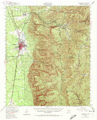
1950 Map of Alamogordo
USGS Topo · Published 1972About this map
Alamogordo sits at the foot of the Sacramento Mountains, serving as a hub where the Southern Pacific railroad and the Aqueduct meet the high desert floor. The landscape is defined by the sharp transition from the flatlands, home to the Alamogordo Airport and White Sands Airport, to the intricate network of canyons like La Luz Canyon and Fresnal Canyon. This 1950s era survey highlights specialized institutions such as the State Sch For Blind and recreational sites like the YMCA Skyline Ranch nestled among the peaks. Industrial history is visible in the higher elevations through the Courtney Mine and Warnock Mine, reflecting a time when mountain resources were actively pursued. Smaller settlements such as High Rolls, Mountain Park, and the ruins at Kearney provide a clear view of how high-altitude communities and orchards were integrated into the Lincoln National Forest.
Find a feature on this map
55 named features on this map. Tap any name to fly to it.
Don’t see what you’re looking for? This feature index may not catch every label — zoom into the map to look around manually.
Map Details
Editions of this 1950 Alamogordo Map
Other maps of this area

1916 · Tularosa
USGS Topo · 1:125,000

1916 · Point Of Sands
USGS Topo · 1:125,000

1948 · Tres Hermanos
USGS Topo · 1:62,500

1948 · Tularosa
USGS Topo · 1:62,500

1948 · Holloman
USGS Topo · 1:62,500

1950 · Escondido Canyon
USGS Topo · 1:62,500

1950 · Alamogordo
USGS Topo · 1:62,500

1950 · Mescalero
USGS Topo · 1:62,500

1952 · Cloudcroft
USGS Topo · 1:62,500

1954 · Carlsbad
USGS Topo · 1:250,000