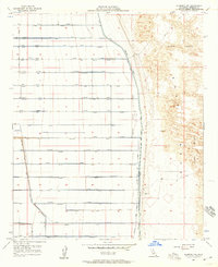
1957 Map of Alamorio NE
USGS Topo · Published 1958About this map
East Mesa provides a stark contrast between engineered agricultural development and raw desert terrain in this mid-century survey of Imperial County. To the west, a highly organized grid of irrigation and drainage infrastructure, including the Moss Lateral, Oasis Lateral, and Pansy Lateral, defines the landscape. This intricate network of laterals and drains—each named after flora or natural elements—illustrates the intensive effort to reclaim and cultivate the desert floor. In striking opposition, the eastern portion of the map is dominated by the shifting topography of the Sand Dunes. The transition between these two worlds is marked by a prominent Levee and the Jeep Trail, highlighting the literal edge of cultivation. Small-scale industrial and transport features like a Gravel Pit and a remote Landing Strip punctuate the grid, serving the logistical needs of this specialized agricultural zone.
Find a feature on this map
48 named features on this map. Tap any name to fly to it.
Don’t see what you’re looking for? This feature index may not catch every label — zoom into the map to look around manually.
Map Details
Editions of this 1957 Alamorio NE Map
4 editions found
Other maps of this area

1907 · Holtville
USGS Topo · 1:125,000

1940 · Iris
USGS Topo · 1:62,500

1940 · Alamorio
USGS Topo · 1:62,500

1942 · El Centro
USGS Topo · 1:250,000

1945 · Alamorio
USGS Topo · 1:62,500

1945 · Iris
USGS Topo · 1:62,500

1953 · Acolita
USGS Topo · 1:24,000

1953 · Acolita
USGS Topo · 1:62,500

1954 · El Centro
USGS Topo · 1:250,000

1954 · Salton Sea
USGS Topo · 1:250,000