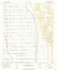
1957 Map of Holtville NE
USGS Topo · Published 1962About this map
Irrigation infrastructure and natural desert landscapes meet in this mid-century survey of Imperial County. The meticulously planned water delivery system is evident in the grid of lateral canals and drains, including the Moss Lateral, Orchid Lateral, and Oasis Lateral, which transformed this arid environment into productive land. This geometric human footprint terminates abruptly at the eastern edge of the agricultural zone, where the East Highline Canal separates the cultivated fields from the natural Mesa and shifting Sand Dunes.
Find a feature on this map
52 named features on this map. Tap any name to fly to it.
Don’t see what you’re looking for? This feature index may not catch every label — zoom into the map to look around manually.
Map Details
Editions of this 1957 Holtville NE Map
4 editions found
Other maps of this area

1907 · Holtville
USGS Topo · 1:125,000

1940 · Iris
USGS Topo · 1:62,500

1940 · Alamorio
USGS Topo · 1:62,500

1942 · El Centro
USGS Topo · 1:250,000

1945 · Alamorio
USGS Topo · 1:62,500

1945 · Iris
USGS Topo · 1:62,500

1953 · Acolita
USGS Topo · 1:24,000

1953 · Acolita
USGS Topo · 1:62,500

1954 · El Centro
USGS Topo · 1:250,000

1954 · Salton Sea
USGS Topo · 1:250,000