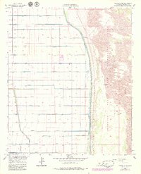
1957 Map of Holtville NE
USGS Topo · Published 1979About this map
The East Highline Canal serves as a sharp hydrological boundary in the California desert, separating the intensely irrigated agricultural plots of the Imperial Valley from the arid expanse of the Imperial Sand Dunes Recreation Area. To the west, a dense network of water management features, including the Holtville Main Drain and an alphabetized series of laterals from Oasis Lateral Drain to Pomelo Lateral Drain, illustrates the complex engineering required to sustain desert farming. This 1957 survey, with revisions into the late 1970s, captures a landscape defined by industrial agriculture and resource extraction, evidenced by a Landing Strip and a Gravel Pit near the canal. The transition from the rigid grid of the valley to the fluid topography of the Sand Dunes reflects the environmental contrast of the Imperial County borderlands.
Find a feature on this map
27 named features on this map. Tap any name to fly to it.
Don’t see what you’re looking for? This feature index may not catch every label — zoom into the map to look around manually.
Map Details
Editions of this 1957 Holtville NE Map
4 editions found
Other maps of this area

1907 · Holtville
USGS Topo · 1:125,000

1940 · Iris
USGS Topo · 1:62,500

1940 · Alamorio
USGS Topo · 1:62,500

1942 · El Centro
USGS Topo · 1:250,000

1945 · Alamorio
USGS Topo · 1:62,500

1945 · Iris
USGS Topo · 1:62,500

1953 · Acolita
USGS Topo · 1:24,000

1953 · Acolita
USGS Topo · 1:62,500

1954 · El Centro
USGS Topo · 1:250,000

1954 · Salton Sea
USGS Topo · 1:250,000