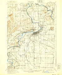
1916 Map of Albany
USGS Topo · Published 1939About this map
The Willamette River and Santiam River converge in this Willamette Valley landscape, where river-based transport and early rail networks intersect. This survey, conducted by the U.S. Geological Survey in cooperation with the State Engineer, captures the region before extensive modernization. Ferries such as Fischer Ferry, Stahlbusch Ferry, and Williams Ferry still serve as vital river crossings, while the Albany Ditch suggests early water management for the growing hub of Albany.
Find a feature on this map
97 named features on this map. Tap any name to fly to it.
Don’t see what you’re looking for? This feature index may not catch every label — zoom into the map to look around manually.
Map Details
Editions of this 1916 Albany Map
4 editions found

Other maps of this area

1911 · Brownsville
USGS Topo · 1:31,680

1911 · Lebanon
USGS Topo · 1:31,680

1911 · Tangent
USGS Topo · 1:31,680

1911 · Inavale
USGS Topo · 1:31,680

1912 · Jefferson
USGS Topo · 1:31,680

1912 · Halsey
USGS Topo · 1:62,500

1913 · Philomath
USGS Topo · 1:31,680

1913 · Oakville
USGS Topo · 1:31,680

1913 · Wells
USGS Topo · 1:31,680

1914 · Independence
USGS Topo · 1:31,680