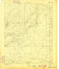
1893 Map of Albany
USGS Topo · Published 1900About this map
The high plains along the Colorado Kansas Boundary Line are defined by the intersection of historic overland routes and scattered ranching settlements in the late nineteenth century. The legendary Santa Fe Trail cuts across the northwest corner, while the north-south Texas Trail skirts the eastern border, marking the area as a vital corridor for western migration and cattle drives. Small outposts such as Albany and Minneapolis serve as central points for the surrounding landscape, anchored by the Kline Ranche near the headwaters of Plum Creek. The terrain is characterized by a network of drainage systems including Sand Arroyo, Horse Creek, and Two Butte Creek, which lead toward the prominent landmark of Two Butte on the western edge. These water sources, alongside Butte Springs, were essential for the survival of early residents and travelers crossing this arid stretch of the High Plains.
Find a feature on this map
23 named features on this map. Tap any name to fly to it.
Don’t see what you’re looking for? This feature index may not catch every label — zoom into the map to look around manually.
Map Details
Editions of this 1893 Albany Map
5 editions found
Other maps of this area

1890 · Granada
USGS Topo · 1:125,000

1891 · Albany
USGS Topo · 1:125,000

1891 · Springfield
USGS Topo · 1:125,000

1892 · Lamar
USGS Topo · 1:125,000

1892 · Vilas
USGS Topo · 1:125,000

1892 · Granada
USGS Topo · 1:125,000

1892 · Two Butte
USGS Topo · 1:125,000

1893 · Two Butte
USGS Topo · 1:125,000

1893 · Springfield
USGS Topo · 1:125,000

1893 · Albany
USGS Topo · 1:125,000