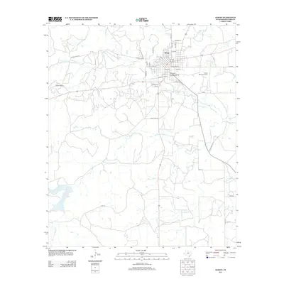
2012 Map of Albany
USGS Topo · Published 2012About this map
The Shackelford County Courthouse Historic District serves as the focal point for Albany, where the local street grid intersects with regional routes like FM 1084 and FM 601. This 2012 survey illustrates the settlement's relationship with its water resources and infrastructure, featuring the Albany Municipal Airport to the east and the significant expanse of McCarty Lake to the southwest. The terrain is defined by a series of winding waterways, including Cook Cr, Indian Cr, and the several branches of the Salt Prong Hubbard Cr. These creeks weave through a landscape marked by rural ranch roads and private drives, such as Newell Ranch Rd and Private Road 2310, reflecting the ranching heritage of the Texas Rolling Plains. The map details the transition from the structured town blocks near Central St to the sprawling hillsides and named estates on the periphery.
Find a feature on this map
47 named features on this map. Tap any name to fly to it.
Don’t see what you’re looking for? This feature index may not catch every label — zoom into the map to look around manually.
Map Details
Editions of this 2012 Albany Map
This is the sole edition of this map. No revisions or reprints were ever made.
Other maps of this area

1892 · Albany
USGS Topo · 1:125,000

1893 · Albany
USGS Topo · 1:125,000

1954 · Abilene
USGS Topo · 1:250,000

1958 · Abilene
USGS Topo · 1:250,000

1965 · Acampo
USGS Topo · 1:24,000

1965 · Albany
USGS Topo · 1:24,000
1965 · Collins Creek SW
USGS Topo · 1:24,000

1965 · McCatherine Mountain
USGS Topo · 1:24,000
1965 · Murphy Creek
USGS Topo · 1:24,000
1965 · Round Hill
USGS Topo · 1:24,000