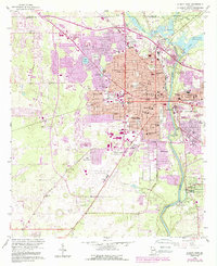
1956 Map of Albany West
USGS Topo · Published 1988About this map
The Flint River carves a path through this southwest Georgia landscape, serving as the eastern boundary for the city of Albany. In the mid-1950s, the urban center was expanding westward, marked by a dense network of schools such as Palmyra Sch and Highland Sch, and the campus of Albany State College along the riverbank. Beyond the city grid, the terrain transitions into a mix of orchards and open fields, anchored by the Albany Dougherty County Airport and the Herty State Nursery.
Find a feature on this map
66 named features on this map. Tap any name to fly to it.
Don’t see what you’re looking for? This feature index may not catch every label — zoom into the map to look around manually.
Map Details
Editions of this 1956 Albany West Map
4 editions found
Other maps of this area

1953 · Dothan
USGS Topo · 1:250,000

1954 · Dothan
USGS Topo · 1:250,000

1955 · Dothan
USGS Topo · 1:250,000

1956 · Albany East
USGS Topo · 1:24,000

1956 · Albany West
USGS Topo · 1:24,000

1956 · Baconton
USGS Topo · 1:62,500

1956 · Newton
USGS Topo · 1:62,500

1956 · Sasser
USGS Topo · 1:62,500

1956 · Albany
USGS Topo · 1:62,500

1973 · Sasser
USGS Topo · 1:24,000