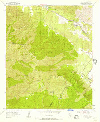
1954 Map of Alberhill
USGS Topo · Published 1957About this map
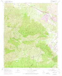
Clay mining and extraction activities define the industrial landscape of Alberhill in the mid-1950s, where several Clay Pits, Dumps, and a Quarry are clustered near the Atchison Topeka and Santa Fe railroad line. This northern corridor of the Temescal Valley contrasts sharply with the high elevations of the Cleveland National Forest to the southwest. The rugged Santa Ana Mountains are mapped in detail, including the Main Divide Truck Trail which follows the ridge between Riverside and Orange counties, passing prominent heights like Trabuco Peak and Los Pinos Peak. Deep within the forest canyons, the map records more secluded sites such as the McConville Nudist Camp and the Old Dominion Mine. Transport through the southern portion of the quadrangle is facilitated by the Ortega Highway, which winds past the El Cariso Guard Sta through the Elsinore Mountains.
Find a feature on this map
39 named features on this map. Tap any name to fly to it.
Don’t see what you’re looking for? This feature index may not catch every label — zoom into the map to look around manually.
Map Details
Editions of this 1954 Alberhill Map
7 editions found
Other maps of this area

1901 · Southern California Sheet No. 1
USGS Topo · 1:250,000

1901 · Elsinore
USGS Topo · 1:125,000

1901 · Riverside
USGS Topo · 1:62,500

1902 · Corona
USGS Topo · 1:125,000

1904 · Southern California Sheet No. 1
USGS Topo · 1:250,000

1942 · Lake Elsinore
USGS Topo · 1:62,500

1942 · Santiago Peak
USGS Topo · 1:62,500

1942 · Corona
USGS Topo · 1:62,500

1942 · Riverside
USGS Topo · 1:62,500
1943 · Corona
USGS Topo · 1:62,500