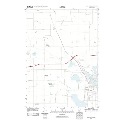
2010 Map of Albert Lea West
USGS Topo · Published 2010About this map
The agrarian landscape of Freeborn County is defined by a complex network of drainage systems, including Judicial Ditch Number Five and County Ditch Number Nine, which navigate the glacial topography north of Albert Lea. Small crossroads communities like Manchester and Armstrong serve as anchors for the surrounding farms, with the Manchester Post Office marking the village center. The map reveals a transition from these open fields to the suburban fringes of the city, where residential streets like Edgewater Dr and W Richway Dr wrap around the northern shores of Fountain Lake.
Find a feature on this map
44 named features on this map. Tap any name to fly to it.
Don’t see what you’re looking for? This feature index may not catch every label — zoom into the map to look around manually.
Map Details
Editions of this 2010 Albert Lea West Map
This is the sole edition of this map. No revisions or reprints were ever made.
Other maps of this area

1954 · Albert Lea
USGS Topo · 1:62,500

1954 · Mason City
USGS Topo · 1:250,000

1955 · Wells
USGS Topo · 1:62,500

1957 · Mason City
USGS Topo · 1:250,000

1958 · Mason City
USGS Topo · 1:250,000

1967 · Freeborn
USGS Topo · 1:24,000

1967 · Hartland
USGS Topo · 1:24,000

1967 · Ellendale
USGS Topo · 1:24,000

1982 · Albert Lea West
USGS Topo · 1:24,000
1982 · Emmons
USGS Topo · 1:24,000