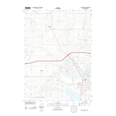
2013 Map of Albert Lea West
USGS Topo · Published 2013About this map
Albert Lea and its western outskirts anchor this 2013 topographic study, revealing a landscape defined by an extensive network of drainage infrastructure and glacial lakes. The presence of numerous engineered waterways, such as Judicial Ditch Number Twentyone, County Ditch Number Fiftyeight, and County Ditch Number Sixtyeight, illustrates the historical effort to manage the high water table of Freeborn County for agricultural use. These ditches weave through a terrain dotted with natural water bodies like Fountain Lake and Pickerel Lake. For genealogists, the map preserves the locations of several burial grounds, including Graceland Cem and the Concordia Lutheran Church Cem of Pickerel Lake. Smaller communities such as Manchester and Armstrong serve as local crossroads, while the Post Office in Manchester marks a central point for the surrounding rural section lines.
Find a feature on this map
49 named features on this map. Tap any name to fly to it.
Don’t see what you’re looking for? This feature index may not catch every label — zoom into the map to look around manually.
Map Details
Editions of this 2013 Albert Lea West Map
This is the sole edition of this map. No revisions or reprints were ever made.
Other maps of this area

1954 · Albert Lea
USGS Topo · 1:62,500

1954 · Mason City
USGS Topo · 1:250,000

1955 · Wells
USGS Topo · 1:62,500

1957 · Mason City
USGS Topo · 1:250,000

1958 · Mason City
USGS Topo · 1:250,000

1967 · Freeborn
USGS Topo · 1:24,000

1967 · Hartland
USGS Topo · 1:24,000

1967 · Ellendale
USGS Topo · 1:24,000

1982 · Albert Lea West
USGS Topo · 1:24,000
1982 · Emmons
USGS Topo · 1:24,000