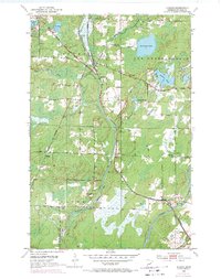
1953 Map of Alborn
USGS Topo · Published 1971About this map
The Duluth Missabe and Iron Range Railroad forms the backbone of this northern Minnesota landscape, creating a vital industrial corridor through St. Louis County. At Coleraine Junction, rail lines branch off to serve the iron-rich hinterlands, while the small settlement of Alborn acts as a central hub for the surrounding rural townships. The map reveals a community defined by its proximity to water and iron, with homes and structures clustered near Artichoke Lake and along the winding Artichoke River.
Find a feature on this map
31 named features on this map. Tap any name to fly to it.
Don’t see what you’re looking for? This feature index may not catch every label — zoom into the map to look around manually.
Map Details
Editions of this 1953 Alborn Map
3 editions found
Other maps of this area

1953 · Canyon
USGS Topo · 1:24,000

1953 · Saginaw
USGS Topo · 1:24,000

1953 · Payne
USGS Topo · 1:24,000

1953 · Alborn
USGS Topo · 1:24,000

1953 · Brookston
USGS Topo · 1:24,000

1953 · Independence
USGS Topo · 1:24,000

1953 · Brookston NW
USGS Topo · 1:24,000

1953 · Duluth
USGS Topo · 1:250,000

1954 · Martin Lake
USGS Topo · 1:24,000

1954 · Hibbing
USGS Topo · 1:250,000