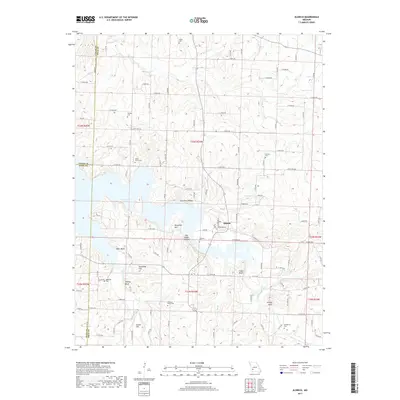
2017 Map of Aldrich
USGS Topo · Published 2017About this map
The Little Sac River and the expansive waters of Stockton Lake dominate this Polk County landscape, illustrating a geography defined by the intersection of river valleys and modern water management. The settlement of Aldrich sits at the transition between the rolling uplands and the lake's fingers, which reach into terrain marked by named landmarks like Cedar Bluff and Tommy Bluff. The survey provides a clear look at the rural cemetery network essential for genealogical research, documenting family and community sites such as Akard Cem, Henderson Cem, and Shady Grove Cem.
Find a feature on this map
103 named features on this map. Tap any name to fly to it.
Don’t see what you’re looking for? This feature index may not catch every label — zoom into the map to look around manually.
Map Details
Editions of this 2017 Aldrich Map
This is the sole edition of this map. No revisions or reprints were ever made.
Other maps of this area

1884 · Springfield
USGS Topo · 1:125,000

1884 · Bolivar
USGS Topo · 1:125,000

1886 · Stockton
USGS Topo · 1:125,000

1886 · Greenfield
USGS Topo · 1:125,000

1886 · Springfield
USGS Topo · 1:125,000

1888 · Greenfield
USGS Topo · 1:125,000

1892 · Bolivar
USGS Topo · 1:125,000

1950 · Cliquot
USGS Topo · 1:24,000
1951 · Cliquot
USGS Topo · 1:24,000

1954 · Springfield
USGS Topo · 1:250,000