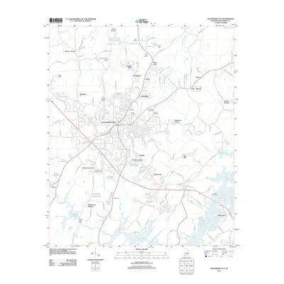
2011 Map of Alexander City
USGS Topo · Published 2011About this map
Alexander City serves as the central hub of this Tallapoosa County landscape, surrounded by residential developments like Indian Hills, Morningside, and Sherwood Forest. The map documents the city's infrastructure and community life through its numerous burial grounds, including the Bethel, Harper, and Hillview cemeteries. Education and industry are closely tied to the area's water resources, as seen at the Alexander City State Junior College Dam and the Russell Mills Dam on Sugar Creek. To the south, the terrain opens into the fingers of Martin Lake, where communities like River Bend and landmarks such as the Lake Hill Marina highlight the area's transition into a recreational and residential lakefront. The northern reaches maintain a more rural character, defined by Oaktasasi Creek and the smaller settlement of Pearson Chapel.
Find a feature on this map
170 named features on this map. Tap any name to fly to it.
Don’t see what you’re looking for? This feature index may not catch every label — zoom into the map to look around manually.
Map Details
Editions of this 2011 Alexander City Map
This is the sole edition of this map. No revisions or reprints were ever made.
Other maps of this area

1890 · Talladega
USGS Topo · 1:125,000

1891 · Ashland
USGS Topo · 1:125,000

1892 · Talladega
USGS Topo · 1:125,000

1901 · Wetumpka
USGS Topo · 1:125,000

1903 · Wetumpka
USGS Topo · 1:125,000

1906 · Dadeville
USGS Topo · 1:125,000

1944 · Goodwater
USGS Topo · 1:62,500

1947 · Goodwater
USGS Topo · 1:62,500

1953 · Montgomery
USGS Topo · 1:250,000

1953 · Birmingham
USGS Topo · 1:250,000
Featured Places
- Alexander City, AL
- Andrew Jackson, AL
- Fuller, Alexander City
- Pearson Chapel, AL
- Indian Hills, Alexander City