
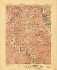
1936 Map of Alexandria
USGS Topo · Published 1936About this map
The Licking River carves a dramatic serpentine path through the heart of Campbell and Kenton Counties, defining a landscape of high ridges and narrow valleys centered on Alexandria. During this era between the world wars, the region's transport network relied on the Louisville & Nashville RR following the river's bends and the Chesapeake & Ohio RR hugging the Ohio River to the east. This survey reveals a dense rural infrastructure of small crossroads and family-named schools, such as Grants Lick Sch and Sylvan Dell Sch.
Find a feature on this map
95 named features on this map. Tap any name to fly to it.
Don’t see what you’re looking for? This feature index may not catch every label — zoom into the map to look around manually.
Map Details
Editions of this 1936 Alexandria Map
2 editions found
Other maps of this area

1898 · East Cincinnati
USGS Topo · 1:62,500

1914 · East Cincinnati
USGS Topo · 1:62,500

1914 · West Cincinnati
USGS Topo · 1:62,500

1914 · Batavia
USGS Topo · 1:48,000

1916 · Batavia
USGS Topo · 1:62,500

1929 · Alexandria
USGS Topo · 1:48,000

1930 · Falmouth
USGS Topo · 1:48,000

1931 · Felicity
USGS Topo · 1:62,500

1936 · Falmouth
USGS Topo · 1:62,500

1950 · Williamstown
USGS Topo · 1:24,000