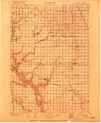
1899 Map of Alexandria
USGS Topo · Published 1917About this map
The James River carves a deep valley through the western edge of this prairie landscape, serving as a primary topographic landmark for early Hanson County settlers. Surveyed in the mid-1890s, the map reveals a meticulously organized township system where rural life revolves around the expansion of regional rail lines. The Alexandria townsite sits at the center of this network, positioned along the Chicago Milwaukee and St. Paul R. R. line which connects several small agricultural hubs. To the south, the village of Rockport is established near the river banks, while the eastern plains are dotted with budding settlements like Spencer, Emery, and Bridgewater. This era shows the transition from open prairie to a structured farming economy, defined by the placement of Pierre Creek and Wolf Creek drainage systems which dictated early road and rail placement through townships such as Edgerton and Jasper.
Find a feature on this map
60 named features on this map. Tap any name to fly to it.
Don’t see what you’re looking for? This feature index may not catch every label — zoom into the map to look around manually.
Map Details
Editions of this 1899 Alexandria Map
5 editions found
Other maps of this area

1898 · Olivet
USGS Topo · 1:125,000

1898 · Parker
USGS Topo · 1:125,000

1898 · Huron
USGS Topo · 1:125,000

1899 · Mitchell
USGS Topo · 1:125,000

1899 · Alexandria
USGS Topo · 1:125,000

1899 · De Smet
USGS Topo · 1:125,000

1953 · Huron
USGS Topo · 1:250,000

1953 · Watertown
USGS Topo · 1:250,000

1954 · Huron
USGS Topo · 1:250,000

1955 · Sioux Falls
USGS Topo · 1:250,000