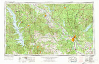
1953 Map of Alexandria
USGS Topo · Published 1975About this map
The Red River valley dominates this mid-century look at Central Louisiana, anchoring the regional hub of Alexandria and neighboring Pineville. This era reveals a landscape defined by significant federal and state land management, including the expansive Kisatchie National Forest and the Fort Polk Military Reservation. To the west, the Toledo Bend Reservoir and Sabine River mark the border with Texas, while the eastern reaches are characterized by the wetlands of Catahoula Lake and the confluence of the Little River.
Find a feature on this map
232 named features on this map. Tap any name to fly to it.
Don’t see what you’re looking for? This feature index may not catch every label — zoom into the map to look around manually.
Map Details
Editions of this 1953 Alexandria Map
3 editions found

Other maps of this area

1932 · Colfax NE
USGS Topo · 1:31,680

1932 · Boyce NE
USGS Topo · 1:31,680

1932 · Boyce SW
USGS Topo · 1:31,680

1932 · Colfax SW
USGS Topo · 1:31,680

1932 · Colfax SE
USGS Topo · 1:31,680

1932 · Colfax NW
USGS Topo · 1:31,680

1935 · Hagewood
USGS Topo · 1:31,680

1935 · Pawnee
USGS Topo · 1:31,680

1935 · Verda
USGS Topo · 1:31,680

1935 · Turkey Creek
USGS Topo · 1:62,500