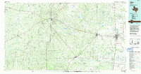
1985 Map of Alice
USGS Topo · Published 1992About this map
The oil fields of Duval and Jim Wells counties dominate this mid-1980s landscape, illustrating a region defined by extensive industrial development. Major operations like the Government Wells Oil Field and Seven Sisters Oil Field are shown in relation to established settlements such as Freer, San Diego, and Alice. The map captures the infrastructure supporting this economy, including the Alice International Airport and specialized military aviation sites like Orange Grove Field (U.S. Navy).
Find a feature on this map
53 named features on this map. Tap any name to fly to it.
Don’t see what you’re looking for? This feature index may not catch every label — zoom into the map to look around manually.
Map Details
Editions of this 1985 Alice Map
2 editions found
Other maps of this area

1917 · Ben Bolt
USGS Topo · 1:62,500

1920 · Mikeska
USGS Topo · 1:125,000

1920 · San Diego
USGS Topo · 1:62,500

1921 · Falfurrias
USGS Topo · 1:125,000

1925 · Mathis No. 3
USGS Topo · 1:48,000

1927 · Mathis
USGS Topo · 1:62,500

1928 · Sarita
USGS Topo · 1:125,000

1929 · Cotulla
USGS Topo · 1:125,000

1937 · Loma Alta
USGS Topo · 1:62,500

1937 · Aguilete Creek
USGS Topo · 1:62,500