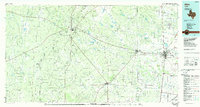
1985 Map of Alice
USGS Topo · Published 1985About this map
Government Wells Oil Field and the surrounding Lundell Oil Field anchor the western portion of this mid-1980s landscape, illustrating the intense petroleum development across the South Texas plains. The region is defined by a network of drainage systems like San Diego Creek and Agua Poquita Creek that cut through the ranchlands between established hubs. Commercial and transit activity centers on Alice and San Diego, where the Texas Mexican and Southern Pacific railroads converge to move goods toward the coast. Aviation infrastructure is prominent with both a local County Airport and the Orange Grove Field (U.S. Navy) facility. Smaller settlements like Palito Blanco and Benavides dot the brush country, while Collins Cem provides a specific point of interest for genealogists tracking local families in Jim Wells and Duval counties.
Find a feature on this map
76 named features on this map. Tap any name to fly to it.
Don’t see what you’re looking for? This feature index may not catch every label — zoom into the map to look around manually.
Map Details
Editions of this 1985 Alice Map
2 editions found
Other maps of this area

1917 · Ben Bolt
USGS Topo · 1:62,500

1920 · Mikeska
USGS Topo · 1:125,000

1920 · San Diego
USGS Topo · 1:62,500

1921 · Falfurrias
USGS Topo · 1:125,000

1925 · Mathis No. 3
USGS Topo · 1:48,000

1927 · Mathis
USGS Topo · 1:62,500

1928 · Sarita
USGS Topo · 1:125,000

1929 · Cotulla
USGS Topo · 1:125,000

1937 · Loma Alta
USGS Topo · 1:62,500

1937 · Aguilete Creek
USGS Topo · 1:62,500