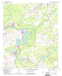
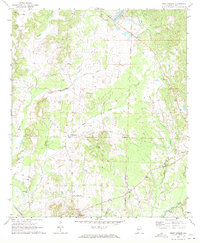
1970 Map of Aliceville South
USGS Topo · Published 1987About this map
The Tombigbee River corridor in Pickens County defines this landscape during a period of significant hydraulic transition. The 1980s-era revisions, marked in purple, document the massive scale of the Tennessee-Tombigbee Waterway, including the Cochrane Cutoff and the expansion of Gainesville Lake. These engineering projects stand in contrast to the traditional river geography, where the Lubbub Creek and Sipsey River meet the main channel amidst a series of oxbows like Moon Lake and the Dead River. Along the western bank, the settlement of Cochrane and the Cochrane Bridge Gaging Sta serve as key landmarks. Away from the water, the map records rural genealogy through the sites of New Canaan Ch, Providence Ch, and several family burial grounds such as Trantham Cem. The northern edge captures the outskirts of Aliceville, including the George Downer Airport and the Burlington Northern railroad lines.
Find a feature on this map
34 named features on this map. Tap any name to fly to it.
Don’t see what you’re looking for? This feature index may not catch every label — zoom into the map to look around manually.
Map Details
Editions of this 1970 Aliceville South Map
3 editions found

Other maps of this area

1953 · Meridian
USGS Topo · 1:250,000

1953 · West Point
USGS Topo · 1:250,000

1957 · Meridian
USGS Topo · 1:250,000

1958 · West Point
USGS Topo · 1:250,000

1963 · West Point
USGS Topo · 1:250,000

1965 · Meridian
USGS Topo · 1:250,000

1970 · Aliceville North
USGS Topo · 1:24,000
1970 · Cunningham
USGS Topo · 1:24,000
1970 · Pleasant Ridge
USGS Topo · 1:24,000
1970 · West Greene
USGS Topo · 1:24,000