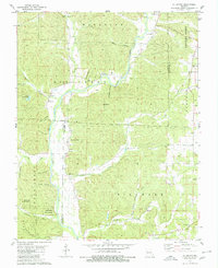
1980 Map of Allbright
USGS Topo · Published 1980About this map
The Castor River meanders through this landscape on the border of Madison, Bollinger, and Wayne counties, anchoring a network of remote valleys and family-named hollows. In the 1970s, this area remained largely rural, defined by small settlements like Allbright and Castor and the expansive Coldwater State Forest. The map is particularly valuable for genealogists, as it documents numerous small rural burial grounds and houses of worship, including Kinder Chapel Cem, Millers Chapel, and Blaylock Cem.
Find a feature on this map
60 named features on this map. Tap any name to fly to it.
Don’t see what you’re looking for? This feature index may not catch every label — zoom into the map to look around manually.
Map Details
Editions of this 1980 Allbright Map
This is the sole edition of this map. No revisions or reprints were ever made.
Other maps of this area

1930 · Coldwater
USGS Topo · 1:62,500

1933 · Marquand
USGS Topo · 1:62,500

1934 · Greenville
USGS Topo · 1:62,500

1935 · Zalma
USGS Topo · 1:62,500

1938 · Marquand
USGS Topo · 1:62,500

1939 · Greenville
USGS Topo · 1:62,500

1939 · Zalma
USGS Topo · 1:62,500

1949 · Rolla
USGS Topo · 1:250,000

1949 · Coldwater
USGS Topo · 1:62,500

1953 · Rolla
USGS Topo · 1:250,000