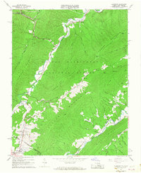
1966 Map of Alleghany
USGS Topo · Published 1968About this map
Dunlap Creek carves a narrow valley through the center of this terrain, following a path shared by the Chesapeake and Ohio railroad and Interstate 64. This mid-1960s survey captures the high-elevation boundary between Virginia and West Virginia, anchored by the settlement of Alleghany and the prominent Lewis Tunnel. The landscape is defined by the steep ridges of Peters Mountain and Dameron Mountain, where isolated communities like Hematite and Crows sit along the creek bed. Near the southern border, the map details the mineral spring heritage of the region at Sweet Chalybeate and Sweet Springs. Several rural congregations are recorded, including Palestine Ch and Forrest Memorial Ch, alongside local landmarks like Beaverdam Falls and the Lewis Tunnel Cem. Much of the eastern portion is protected within the George Washington National Forest, showing a network of mountain runs and hollows such as Cast Steel Run and Jack Tucker Hollow.
Find a feature on this map
64 named features on this map. Tap any name to fly to it.
Don’t see what you’re looking for? This feature index may not catch every label — zoom into the map to look around manually.
Map Details
Editions of this 1966 Alleghany Map
Other maps of this area

1887 · Lewisburg
USGS Topo · 1:125,000

1891 · Lewisburg
USGS Topo · 1:125,000

1921 · Callaghan
USGS Topo · 1:48,000

1921 · White Sulphur Springs
USGS Topo · 1:48,000

1921 · Ronceverte
USGS Topo · 1:48,000

1923 · White Sulphur Springs
USGS Topo · 1:62,500

1923 · Ronceverte
USGS Topo · 1:62,500

1923 · Callaghan
USGS Topo · 1:62,500

1935 · White Sulphur Springs
USGS Topo · 1:62,500

1939 · White Sulphur Springs
USGS Topo · 1:62,500