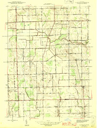
1945 Map of Allenton
USGS Topo · Published 1945About this map
Allenton and Berville anchor this agricultural landscape during the mid-1940s, situated where the borders of St. Clair, Lapeer, and Macomb counties converge. The terrain is defined by a dense network of country roads like Hough Rd and Capac Rd, which connected a series of one-room schoolhouses that served the farming families of the era. The presence of Lockbridge Sch, Gould Sch, and the Scotch Settlement Sch reveals a decentralized social structure centered on local education and worship, exemplified by the West Berlin Ch.
Find a feature on this map
69 named features on this map. Tap any name to fly to it.
Don’t see what you’re looking for? This feature index may not catch every label — zoom into the map to look around manually.
Map Details
Editions of this 1945 Allenton Map
2 editions found
Other maps of this area

1914 · Armada
USGS Topo · 1:62,500

1928 · Armada
USGS Topo · 1:62,500

1943 · Romeo
USGS Topo · 1:24,000

1944 · Memphis
USGS Topo · 1:24,000

1945 · Armada
USGS Topo · 1:24,000

1945 · Almont
USGS Topo · 1:24,000

1945 · Allenton
USGS Topo · 1:24,000

1945 · Richmond
USGS Topo · 1:24,000

1945 · Romeo
USGS Topo · 1:24,000

1952 · Allenton
USGS Topo · 1:24,000