
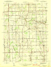
1945 Map of Allenton
USGS Topo · Published 1945About this map
Allenton serves as the central hub of this agricultural landscape in Berlin Township, where small rural communities are linked by a grid of farm-to-market roads. The terrain is defined by the Belle River in the north and the East Branch Coon Creek in the south, which drains the undulating fields toward the county line. The settlement pattern shows a high density of local institutions, including the West Berlin Ch and the distinct Scotch Settlement in the west. This mid-century survey reveals a traditional township structure still reliant on localized infrastructure, featuring numerous rural schoolhouses such as Kelly Sch, Tibbetts Sch, and Brick Sch. The presence of several burial grounds, including East Berlin Cem and Rose Hill Cem, offers significant research value for those tracing family roots in this corner of St. Clair County.
Find a feature on this map
55 named features on this map. Tap any name to fly to it.
Don’t see what you’re looking for? This feature index may not catch every label — zoom into the map to look around manually.
Map Details
Editions of this 1945 Allenton Map
2 editions found
Other maps of this area

1914 · Armada
USGS Topo · 1:62,500

1928 · Armada
USGS Topo · 1:62,500

1943 · Romeo
USGS Topo · 1:24,000

1944 · Memphis
USGS Topo · 1:24,000

1945 · Armada
USGS Topo · 1:24,000

1945 · Almont
USGS Topo · 1:24,000

1945 · Richmond
USGS Topo · 1:24,000

1945 · Romeo
USGS Topo · 1:24,000

1952 · Allenton
USGS Topo · 1:24,000

1952 · Memphis
USGS Topo · 1:24,000