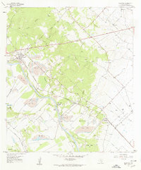
1958 Map of Alleyton
USGS Topo · Published 1959About this map
Alleyton serves as the focal point of this late 1950s survey of Colorado County, where the industrial presence of numerous strip mines and gravel pits contrasts with the riparian landscape of the Colorado River. The rail infrastructure is prominent, featuring the Texas and New Orleans Railroad and the (Southern Pacific) lines, alongside an old railroad grade near Ramsey. Local family history is preserved through a dense concentration of small burial grounds, including the Griewe Cem, Allen Cem, and the Pinchback Obenchain Cem. The map identifies the Alley House (Historical) near the river, signifying the early settlement roots of the region. Broad geographic features like Hahn Bottoms and the Ramsey Gas Field illustrate the dual importance of agriculture and resource extraction in the mid-century Texas economy.
Find a feature on this map
38 named features on this map. Tap any name to fly to it.
Don’t see what you’re looking for? This feature index may not catch every label — zoom into the map to look around manually.
Map Details
Editions of this 1958 Alleyton Map
3 editions found

Other maps of this area

1919 · Fayettsville
USGS Topo · 1:62,500

1953 · Seguin
USGS Topo · 1:250,000

1956 · Bellville
USGS Topo · 1:62,500

1956 · Glidden
USGS Topo · 1:62,500

1957 · Eagle Lake
USGS Topo · 1:62,500

1957 · Altair
USGS Topo · 1:24,000

1957 · Columbus
USGS Topo · 1:24,000

1958 · Seguin
USGS Topo · 1:250,000

1958 · Frelsburg
USGS Topo · 1:24,000

1958 · Bernardo
USGS Topo · 1:24,000