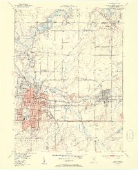
1952 Map of Alliance
USGS Topo · Published 1954About this map
The industrial and academic character of the Alliance area is anchored by the presence of Mt Union College and a robust intersection of major rail lines. This survey captures the region as the New York Central Railroad and Pennsylvania Railroad networks supported the growth of satellite communities like Sebring and Beloit. To the north, the Mahoning River feeds into the Berlin Res, a landscape transition that includes early aviation sites such as Barber Airport and Whiteley Airfield.
Find a feature on this map
74 named features on this map. Tap any name to fly to it.
Don’t see what you’re looking for? This feature index may not catch every label — zoom into the map to look around manually.
Map Details
Editions of this 1952 Alliance Map
3 editions found
Other maps of this area

1906 · Ravenna
USGS Topo · 1:62,500

1908 · Warren
USGS Topo · 1:62,500

1908 · Ravenna
USGS Topo · 1:62,500

1909 · Alliance
USGS Topo · 1:62,500

1909 · Lisbon
USGS Topo · 1:62,500

1950 · Cleveland
USGS Topo · 1:250,000

1951 · Canton
USGS Topo · 1:250,000

1952 · Lake Milton
USGS Topo · 1:24,000

1952 · Alliance
USGS Topo · 1:24,000

1952 · Damascus
USGS Topo · 1:24,000