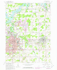
1966 Map of Alliance
USGS Topo · Published 1978About this map
The industrial and academic hub of Alliance serves as the focal point of this mid-1960s survey, highlighting its position at the intersection of the Penn Central railroad and the Mahoning River. The map meticulously documents the campus of Mt Union College alongside numerous neighborhood schools like St Josephs Sch and Wayne Lincoln Sch, reflecting a period of robust institutional growth. Beyond the city center, the landscape transitions into the recreational and resource-driven terrain of Deer Creek State Park and the extensive Berlin Lake reservoir.
Find a feature on this map
73 named features on this map. Tap any name to fly to it.
Don’t see what you’re looking for? This feature index may not catch every label — zoom into the map to look around manually.
Map Details
Editions of this 1966 Alliance Map
Other maps of this area

1906 · Ravenna
USGS Topo · 1:62,500

1908 · Warren
USGS Topo · 1:62,500

1908 · Ravenna
USGS Topo · 1:62,500

1909 · Alliance
USGS Topo · 1:62,500

1909 · Lisbon
USGS Topo · 1:62,500

1950 · Cleveland
USGS Topo · 1:250,000

1951 · Canton
USGS Topo · 1:250,000

1952 · Lake Milton
USGS Topo · 1:24,000

1952 · Alliance
USGS Topo · 1:24,000

1952 · Damascus
USGS Topo · 1:24,000