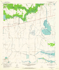
1962 Map of Alligator Hole Marsh
USGS Topo · Published 1964About this map
Hydraulic infrastructure and oil extraction dominate this coastal Jefferson County landscape as it appeared in the early 1960s. The marshy terrain between North Fork Taylor Bayou and South Fork Taylor Bayou is defined by a complex network of pumping stations and pipelines, signaling the region’s role in mid-century industrial expansion. Large-scale petroleum activity is concentrated at the Fannett Oil Field, the La Belle Oil Field, and the Big Hill Oil Field, where numerous wells and compressor stations dot the lowlands.
Find a feature on this map
30 named features on this map. Tap any name to fly to it.
Don’t see what you’re looking for? This feature index may not catch every label — zoom into the map to look around manually.
Map Details
Editions of this 1962 Alligator Hole Marsh Map
This is the sole edition of this map. No revisions or reprints were ever made.
Other maps of this area

1943 · Fannett East
USGS Topo · 1:24,000

1945 · Fannett East
USGS Topo · 1:31,680

1950 · Houston
USGS Topo · 1:250,000

1956 · Houston
USGS Topo · 1:250,000

1961 · Star Lake
USGS Topo · 1:24,000
1961 · Clam Lake
USGS Topo · 1:24,000
1962 · Fannett East
USGS Topo · 1:24,000
1962 · Whites Ranch
USGS Topo · 1:24,000
1962 · Port Acres
USGS Topo · 1:24,000
1962 · Fannett West
USGS Topo · 1:24,000