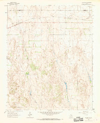
1963 Map of Allison SW
USGS Topo · Published 1969About this map
The Santa Fe And Panhandle railroad cuts a horizontal path across the northern landscape of Wheeler County, marking a primary corridor of transport in the Texas Panhandle during the early 1960s. The terrain is defined by a series of south-flowing drainage systems, most notably Goodin Creek and Coburn Creek, which carve through the plains. The presence of a Flowing Well and several Spring labels along Williams Creek indicate the critical importance of groundwater in this semi-arid ranching region. To the northeast, the land shifts toward Mulberry Draw as it crosses the boundary between Hemphill and Wheeler Counties. Small-scale industrial activity is evidenced by a Gravel Pit located near the western edge of the survey, likely supporting local road maintenance and infrastructure.
Find a feature on this map
9 named features on this map. Tap any name to fly to it.
Don’t see what you’re looking for? This feature index may not catch every label — zoom into the map to look around manually.
Map Details
Editions of this 1963 Allison SW Map
3 editions found
Other maps of this area

1954 · Amarillo
USGS Topo · 1:250,000

1958 · Amarillo
USGS Topo · 1:250,000

1962 · Wheeler
USGS Topo · 1:24,000

1963 · Allison
USGS Topo · 1:24,000

1963 · Kelton
USGS Topo · 1:24,000

1963 · Kelton NW
USGS Topo · 1:24,000

1963 · Briscoe
USGS Topo · 1:24,000

1963 · Allison SW
USGS Topo · 1:24,000

1967 · Dads Creek
USGS Topo · 1:24,000

1967 · Hackberry Creek
USGS Topo · 1:24,000