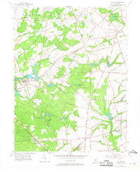
1955 Map of Alloway
USGS Topo · Published 1968About this map
Alloway and its surrounding townships define this mid-century portrait of Salem County, where the agricultural landscape is woven together by an intricate network of waterways and early transport routes. The Pennsylvania-Reading Seashore Lines cuts through the northern half of the map, serving rural outposts like Daretown and Yorktown. The area’s industrial heritage is evident in the numerous water-powered sites such as Elkinton Millpond and Fox Mill, which sit alongside distinctive local landmarks like Big Mannington Hill.
Find a feature on this map
69 named features on this map. Tap any name to fly to it.
Don’t see what you’re looking for? This feature index may not catch every label — zoom into the map to look around manually.
Map Details
Editions of this 1955 Alloway Map
3 editions found
Other maps of this area

1890 · Salem
USGS Topo · 1:62,500

1890 · Bay Side
USGS Topo · 1:62,500

1890 · Bridgeton
USGS Topo · 1:62,500

1890 · Glassboro
USGS Topo · 1:62,500

1894 · Bay Side
USGS Topo · 1:62,500

1894 · Bridgeton
USGS Topo · 1:62,500

1898 · Salem
USGS Topo · 1:62,500

1898 · Glassboro
USGS Topo · 1:62,500

1899 · Vineland
USGS Topo · 1:125,000

1901 · Camden
USGS Topo · 1:125,000
Featured Places
- Hopewell Township, NJ
- Quinton Township, NJ
- Alloway Township, NJ
- Fox Mill, Upper Pittsgrove Township
- Aldine, Alloway Township