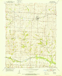
1951 Map of Alma
USGS Topo · Published 1951About this map
The town of Alma sits as the central hub of this 1951 survey, situated along the Gulf Mobile and Ohio railroad. The surrounding Lafayette County landscape is a mosaic of agricultural divisions across the townships of Dover, Middleton, Davis, and Freedom. This era of rural development is marked by a high density of local institutions, including the Flora Sch, Elk Grove Sch, and Brackman Sch, which served the farming communities before the widespread consolidation of school districts.
Find a feature on this map
24 named features on this map. Tap any name to fly to it.
Don’t see what you’re looking for? This feature index may not catch every label — zoom into the map to look around manually.
Map Details
Editions of this 1951 Alma Map
3 editions found

Other maps of this area

1885 · Warrensburg
USGS Topo · 1:125,000

1887 · Sedalia
USGS Topo · 1:125,000

1887 · Warrensburg
USGS Topo · 1:125,000

1889 · Lexington
USGS Topo · 1:125,000

1890 · Marshall
USGS Topo · 1:125,000

1892 · Marshall
USGS Topo · 1:125,000

1894 · Sedalia
USGS Topo · 1:125,000

1894 · Warrensburg
USGS Topo · 1:125,000

1901 · Marshall
USGS Topo · 1:125,000

1917 · Knobnoster
USGS Topo · 1:62,500