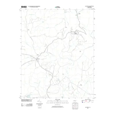
2010 Map of Altamont
USGS Topo · Published 2010About this map
The Cumberland Plateau towns of Altamont and Beersheba Springs anchor this local study of Grundy County. Altamont, the county seat, sits at a major crossroads including Beersheba St and Old State Hwy 56, while Beersheba Springs is located to the northeast near the edge of the plateau. The landscape is defined by the sharp topography of the Collins River valley and the Stone Door geological feature. Genealogists will find a concentration of burial grounds, including the Swiss Colony Cemetery and the Morton Cemetery. The map also documents the Gruetli Gas Field and the waters of Big Creek, showcasing the mix of resource extraction and the natural plateau environment. Remote paths like Savage Gulf Rd and Northcutts Cove Rd wind through the many creeks and branches that drain the high country.
Find a feature on this map
54 named features on this map. Tap any name to fly to it.
Don’t see what you’re looking for? This feature index may not catch every label — zoom into the map to look around manually.
Map Details
Editions of this 2010 Altamont Map
This is the sole edition of this map. No revisions or reprints were ever made.
Other maps of this area

1893 · Mc Minnville
USGS Topo · 1:125,000

1895 · Mc Minnville
USGS Topo · 1:125,000

1895 · Sewanee
USGS Topo · 1:125,000

1936 · Palmer
USGS Topo · 1:24,000

1936 · Burrow Cove
USGS Topo · 1:24,000

1936 · Tracy City
USGS Topo · 1:24,000

1936 · Cane Hollow
USGS Topo · 1:24,000

1943 · Mc Minnville
USGS Topo · 1:100,000
1947 · Burrow Cove
USGS Topo · 1:24,000
1947 · Tracy City
USGS Topo · 1:24,000